1858 General Crawford's Map w/ Morris Island Lighthouse image
$125.00
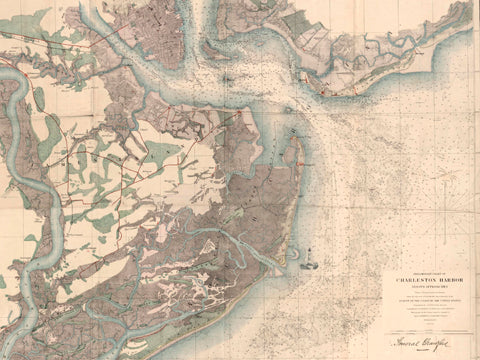
This 1858 Pre-Civil War map, both a military map and a nautical chart, shows the Charleston Harbor and its approaches. It was completed under the direction of Professor Alexander Dallas Bache, superintendent of the Survey of the Coast of the United States from 1844 – 1867, and a professor of Natural Philosophy and Chemistry at the University of Pennsylvania. Bache had been directed to complete a survey of the Mideastern US coastline. This map is named for General Samuel W. Crawford who was a surgeon and General in the US (Union) Army. Crawford was placed in charge of a number of artillery pieces during the initial bombardment of Fort Sumter, April 12 – 13, 1861. This map, created in 1858, has Gen Crawford’s drawings and annotations from the early days of the Civil War. Areas shown include the site of the Battle of Secessionville. It also identifies many other important military sites including Fort Johnson (from which the first shot of the war was fired), Fort Sumter (the fort occupied by Union troops under command of Union Major Robert Anderson at time of the first shot), Fort Wagner (the fort charged by the African American military unit, the 54th Massachusetts out of Boston, MA), as well as Forts Marion and Moultrie on Sullivan’s Island (both heavily armed fortresses).
This image contains a sketch of the Morris Island lighthouse, drawn by Lowcountry Sketches artist Lowry Coe.